

Mount Rinjani with the highest point 3,726 meters above sea level, dominates the view of the majority of the northern part of the island of Lombok.
On the west side there is a cone of Rinjani caldera with an area of approximately 3,500 m × 4.800 m, extends towards the east and the west. There are at Segara Anak caldera (immediately = sea, lake) area of 11,000,000 square meters with a depth of 230 m. The water that flows from the lake have formed a very beautiful waterfall, flowing through a steep ravine. In Segara Anak many carp and tilapia are so frequently used for fishing. The southern part of the lake is called Segara Endut.
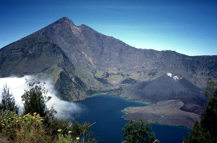
On the east side of the caldera are New Mountain (or Mount Barujari) which has a crater measuring 170m x 200m with a height of 2296-2376 m above sea level. This small mountain last erupted on 25 October 2015 and 3 November 2015, having previously recorded erupted in May 2009 and in 2004. If the eruption in 2004 no casualties, the eruption in 2009 has claimed the lives of 31 people indirectly, because of flooding flash on Kokok (River) Tanggek by the pressure of lava to Segara Anak. Previously, Mount Barujari ever recorded erupted in 1944 (and establishment), 1966 and 1994.
The peak of Mount Rinjani
Climbing Mount Rinjani (peak) is one of the attractions is a mainstay in the area of Mount Rinjani National Park. Mount Rinjani as the volcano is still active 2nd highest number in Indonesia. The peak of Mount Rinjani is the goal of most of the adventurers and nature lovers who visit this area as if it has reached the top it is a matter of pride. Animo community nature lovers across the country and even from abroad in large enough climbing activities, this is proven by the number of visitors who make the climb each year has increased. Climbing activities on a large scale carried out in July s / d in August, in August (mid) participants ascent is generally dominated by the students / students from all over Indonesia who want to celebrate the Independence Day of the Republic of Indonesia on the peak of Mount Rinjani and Segara Anak Lake through activities "Tread Rinjani" held regularly every year by a group of nature lovers on the island of Lombok in cooperation with the National Park of Mount Rinjani.

To reach the summit of Mount Rinjani there are three (3) main line / official, among others:
Senaru path
Senaru hiking trail is the busiest climbing lane, and this is in addition to a trekking tour path is also often used as a hiking trail by the indigenous peoples who will perform traditional rituals / religious at the top of Rinjani or Lake Segara Anak
Climbing route is Senaru - Pelawangan Senaru - Lake Segara Anak foot takes ± 10-12 hours through the tourist trail are located in primary forests and along the trail has provided a means resting on each post .. Along the way the trail visitors can enjoy the beauty of the forest wilderness and stunning rocks

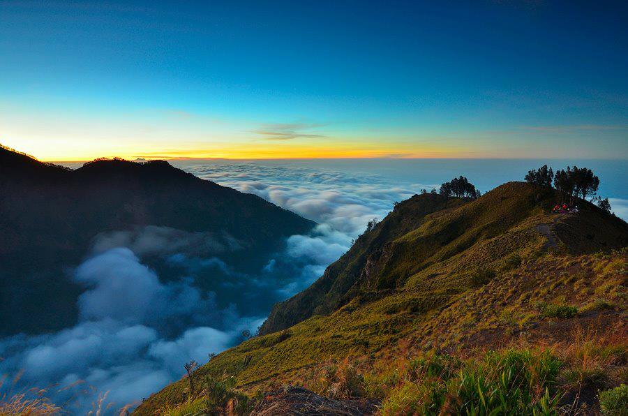
To obtain information about climbing Mount Rinjani has provided Integrated Climbing Center (Rinjani Trek Centre) in cooperation BTNGR with NZAID (New Zealand Asistance International Development). From Lake Segara kids if you want to continue the journey to the summit of Mount Rinjani you have to go to Pelawangan Sembalun with the distance of ± 4 hours, from Pelawangan to the top rinjani takes 4-5 hours. The ascent to the peak is generally carried out at 02 AM, this meant that in the morning, hikers can enjoy the sunrise (Sunrise) from the summit of Mount Rinjani and can enjoy views over the island of Lombok island even if the weather is sunny.
Sembalun
In addition to Senaru path Sembalun path is also a path well-traveled, especially by fans of trekking tour. These are the gates through which Sembalun mace - Pelawangan Sembalun mountaintops rinjani takes 9-10 hours. The line was very dramatic and impressive, the tourist trail you are going through a savanna and ridges winding turns of the gorge on the left and right lanes.
Compared path Senaru, the route is not too steep, but because it is dominated by savanna make your trip sweating by the hot sun scorching, but it will go away when you made were stunned by the beautiful view of the meadows and vast forests along the valleys green in the east of Mount Rinjani, even your eyes will be spoiled by the beauty of the Alas Strait and the island of Sumbawa in the distance. After arriving at the summit of Rinjani you can take a break while enjoying the natural scenery and pride have set foot in one horizon in Indonesia and creates a sense of wonder at His creation.
No comments:
Post a Comment